May 8, 1862 - Shenandoah Valley Campaign: The Battle of McDowell
May 8, 1862
The Battle of McDowell
Highland County, Virginia
Brig. Generals Robert H Milroy and Robert C. Schenck (Union skirmishers from the 32nd Ohio Infantry, 73rd Ohio Infantry, and 3rd West Virginia Infantry; some units from CT too)
vs.
Maj. Gen. Stonewall Jackson (a brigade of five regiments of infantry and two artillery batteries commanded by Brigadier General Charles S. Winder, a brigade of three infantry regiments, an infantry battalion, and two artillery batteries commanded by Colonel John A. Campbell, and a brigade of three infantry regiments and one artillery battery commanded by Brigadier General William B. Taliaferro); reinforced by Brig. Gen. Edward "Allegheny" Johnson (brigade of three infantry regiments commanded by Colonel Zephaniah T. Conner and a second brigade of three infantry regiments commanded by Colonel William C. Scott, all from Virginia, except for one Georgia regiment in Conner's brigade)
* A Confederate strategic victory on the heels of Jackson's defeat at Kernstown, but also preceding additional victories in the Valley. Still - for holding the high ground, they somehow lost more men (and a greater percentage of casualties).
* So, again (like New Market) - I haven't specifically, intentionally visited the Shenandoah Valley Battlefields yet, but I passed McDowell on the way home from West Virginia [Summer 2024], and I couldn't resist. I'll be back!
* Update: March 2026 I finally made it back (See Below) for completion.
"Joining forces with Brig. Gen. Edward "Allegheny" Johnson's Army of the Northwest in early May, 1862, Maj. Gen. Thomas J. “Stonewall” Jackson moved to McDowell, Virginia to intercept the army of Maj. Gen. John C. Fremont gathering west of there. Late in the afternoon of May 8, the head of Jackson's infantry column took a position on Sitlington's Hill, a mile-long rocky spur overlooking the Union camp beside the Bull Pasture River. The brigades of Brig. Gens. Robert H. Milroy and Robert C. Schenck attacked Jackson and Johnson using the cover of ravines and woods. The Federals were repulsed after severe fighting lasting four hours. After the battle, Milroy and Schenck withdrew to the west, freeing up Jackson’s army to return to the Shenandoah Valley. Jackson's victory at McDowell set the stage for his hard-marching, hard-fighting 1862 campaign that, over the next month, kept Union troops penned up in the Valley."
 |
| https://www.hmdb.org/m.asp?m=155460 |
This stately brick house [not pictured LOL] was built about 1855 for Felix Hull (ca. 1823-1861) in the Greek Revival style popular in the late antebellum period. During the Civil War, his widow, Eliza Mathews Hull, was living here on 7-8 May 1862 when the house was commandeered for headquarters by Union Brig. Gen. Robert H. Milroy and his superior, Brig. Gen. Robert C. Schenck. On 9 May, after the Battle of McDowell on Sitlington's Hill just to the east, the victorious Maj. Gen. Thomas J. “Stonewall” Jackson made his headquarters here. He pursued the Union army westward, then returned here on 14 May for the night before moving toward Staunton.
 |
| https://www.hmdb.org/m.asp?m=235814 |
Highway To War
Staunton and Parkersburg Turnpike
During the Civil War, Virginia's roads were of vital importance to both Union and Confederate armies for the transport of soldiers, artillery, supply wagons, and livestock herds to feed the troops. The roads ranged from narrow dirt paths to wide, hard-surfaced highways, such as the Staunton and Parkersburg Turnpike which connected the Shenandoah Valley with the Ohio River.
The turnpike was among the most strategically significant east-west transportation corridors in western Virginia when the war began. The first land battle of the war was fought on the turnpike at Philippi in present-day West Virginia on June 3, 1861. The Union victory at the Battle of Rich Mountain on July 11 gave the Federals control of much of the turnpike and the Tygart River Valley. Confederate Camp Allegheny, located off modern U.S. Route 250 in West Virginia just west of the state line, guarded the road there and was the scene of an engagement on December 13; the Confederates retained control. Both armies used the turnpike in April-May 1862 before and after the Battle of McDowell.
The type of bridge that was here over Crab Run during the war is not known. The current bridge is a rare Lane Truss Bridge. Daniel Lane, owner of the Lane Bridge Company in Painted Post, N.Y., patented the original design in 1890 and improved it in 1894. His design utilized straight and bent railroad and trolley rails made of steel instead of iron trusses. The West Virginia Bridge Works in Wheeling manufactured this bridge in 1896 to carry traffic over the stream on the original alignment of the Staunton and Parkersburg Turnpike. The bridge was listed on the Virginia Landmarks Register and the National Register of Historic Places in 2009.
Beginning in 1823, Claudius Crozet, principal engineer for the Virginia Board of Public Works, supervised the survey of the route of the turnpike. The 15-to-20-foot-wide road was constructed over the next decades with numerous switchbacks and loops along its roughly 230-mile length to maintain a grade of no more than 4 percent. Numerous bridges were built over the mountain streams and rivers; the Philippi Covered Bridge is one of the best known. When the Virginia State Highway Commission improved the turnpike in the 1920s, the present short McDowell bypass was constructed in 1927 as part of U.S. Route 250.
Although U.S. Route 250 follows much of the turnpike route, segments of the original road can be traveled in Virginia on Route 688 (paved) west of Staunton between Buffalo Gap and Route 629 at the Calfpasture River. An unpaved segment is located about 50 miles west of here at Camp Allegheny, just across the West Virginia line, where the old turnpike winds around and down the mountain to Bartow. Four-wheel drive is highly recommended.
Yea, I am familiar with accessing Camp Allegheny via the old turnpike. If I'm not mistaken it was the highest altitude of any encampment in the war. And, no- my little hybrid Hyundai does not have four-wheel drive.
 |
https://www.hmdb.org/m.asp?m=235831
|
 |
| https://www.hmdb.org/m.asp?m=62929 |

 |
| https://www.hmdb.org/m.asp?m=235759 |
This congregation, first known as Central Union Church, was organized in 1822. The present brick sanctuary, an interpretation of the Greek Revival style, replaced an earlier structure ca. 1856. The entrance on the building's south side was likely for the use of free and enslaved African Americans, who worshiped from the balcony. During the Battle of McDowell on 8 May 1862, the church served as a hospital. Union and Confederate dead were reportedly buried in the congregation's cemetery across present-day Route 250. The church is listed on the American Presbyterian and Reformed Historic Sites Registry, the Virginia Landmarks Register, and the National Register of Historic Places.

 |
| https://www.hmdb.org/m.asp?m=235849 |
Neighbor fought neighbor on this ground during the Battle of McDowell. During the fighting, the 3rd Virginia Infantry (Union) moved to your left along the Staunton-Parkersburg Turnpike in an attempt to get around the Confederate right flank. Reaching this area, the Federals were blocked by the Confederate 31st Virginia.
Some of the Confederates moved through the woods to the left and circled to the rear of the Federals. Taking fire from front and back, the Federals defended themselves by wheeling to fire first in one direction, then the other. When orders came for the 31st Virginia to move up to the hill, the southerners who were behind the Federals left and advanced up the hillside.
The remainder of the 31st Virginia continued their private battle with the 3rd Virginia (Union). Remarkably, the opposing sides found themselves firing on their own neighbors. Three companies of the 3rd Virginia (Union) had been recruited from the Clarksburg area in modern-day West Virginia - as had Company C of the Confederate 31st Virginia.
Some members had even served in the same pre-war militia unit. (Stonewall Jackson himself had been born in Clarksburg.) Looking at the enemy from just 100 yards away, they recognized familiar faces. Union soldier Andrew Price late recalled that "The [31st Virginia] came close to the 3rd, and saluted them, and called them by name, and proceeded with the slaughter." Another soldier said that, "The jibes and insults flew as thickly as the bullets." Casualties were relatively light, however, as much of the fire was hurried and high.
The fighting died down when the rest of the 31st Virginia moved up Sitlington's Hill to reinforce the defenses there. Although Stonewall Jackson ordered the 21st Virginia to take their place, the 3rd Virginia (Union) had pulled back, and largescale fighting ended on the turnpike.
And now for some drive-bys. Cut me some slack, as I had just spent 48-hours in West Virginia and was heading home.


 |
| https://www.hmdb.org/m.asp?m=4232 |
Stonewall Jackson, to prevent a junction of Fremont and Banks, took position on the hills just to the south and beat off the attacks of Fremont’s advance under Milroy, May 8, 1862. Milroy retreated that night.
 |
| https://www.hmdb.org/m.asp?m=4283 |
Commemorating The Battle Of McDowell
May 8, 1862
Federals in action 4000, killed and wounded 256.
Confederates in action 2500, killed and wounded 498.
Confederate Officers Killed
Captains Lieutenants
Samuel Dawson John K. Goldwire
William L. Furlow William A. Massey
John McMillan William H. Turpin
James W. Patterson James T. Woodward
All of the 12th Georgia Regiment
Colonel S.P. Gibbons... 10th Virginia Regiment
Captain J. Whitmore ... 25th " "
Captain William Long... 52nd " "
Lieutenant Wm.H. Gregory... 23rd " "
" Charles E. Dyer... 25th " "
" Samuel P. Dye... 37th " "
" C.G. Fletcher ... 37th " "
" John A. Carson... 52nd " "
Erected 1917 by Highland Chapter United Daughters of The Confederacy.
 |
| https://www.hmdb.org/m.asp?m=235927 |
Anthony's Burg
Post-Civil War African American Community
—The Civil War Era in Highland County—
The parking lot you are standing in was built upon land donated by Lt. Col. Leonard Harris, U.S. Army (Ret.), and his cousin John Howard "Duffy" Smith. Their family was deeded property here shortly before the Civil War. Allegedly, Robert Sitlington, a wealthy landowner, gave small parcels of land to enslaved people he had freed, although no such land transfer is noted in his will or other county records.
Harris and Smith's great-grandfather, John Smith, was a free man and a Community leader. Lt. Col. Harris was raised on the property by his grandparents, and he remembered seeing many Civil War artifacts on the old homestead, including a well-preserved rifle and bayonet.
This area was part of a post-war African American community called Anthony's Burg. Most African American families in Highland County lived here or in a nearby community called Flood. According to county records, in 1906, the son of slaveholder George Washington Hull sold 64 acres to Anthony Young. Young sold the land to his fellow black residents, who formed the community of Anthony's Burg.
Churches were established in Anthony's Burg and Flood, including the Pleasant View AME Church in Anthony's Burg, and became centers of activity in their communities. Before the churches were built, African Americans had to sit in the balcony of the McDowell Presbyterian Church.
The survival of Anthony's Burg and Flood depended mainly on the skilled labor of its residents. Unfortunately, the communities were not large enough to support black owned businesses, and as time went on, residents began looking for work and opportunity outside of Highland County. The last resident of Anthony's Burg, Ms. Georgia Pleasant, died in 1975.
This drawing by famed artist W. L. Sheppard depicts African Americans worshipping at church sometime after the Civil War.
This is a post war photo of an African American family. These families faced new hardships after the Civil War.
Image Courtesy of the Encyclopedia of Virginia.
This map shows the approximate locations of the communities of Anthony's Burg and Flood.

At the trailhead...

Battle of McDowell
Sitlington's Hill
The Battle of McDowell was the second engagement of Confederate Gen. "Stonewall" Jackson's Shenandoah Valley Campaign. After being defeated by Union forces at Kernstown, just south of Winchester, on March 23, 1862, Jackson withdrew south in the Valley. In early May, bolstered by reinforcements, he moved west into the mountains to take on Union Gens. Robert Milroy and Robert Schenck, who had been advancing from western Virginia. Stonewall's troops seized Sitlington's Hill in McDowell on May 8, and held it despite several Union assaults. After the battle, Milroy and Schenck retreated north. Jackson returned to the main Valley, where he won four additional victories over Union forces before his legendary campaign ended in mid-June.
"We saw from our position - distant one mile, and on an elevation which commanded the whole ground that there were four rebels to one of our men."
Sgt. G.A. Stevens, 32nd Ohio, describes Sitlington's Hill.
 |
| This lovely (new?) signage from the Shenandoah Valley Battlefields Historic District is not in the database (someone else can get it), though their similar marker for the Battle Of Cross Keys is. Nonetheless, I think we've got it at this point. |
 |
| https://www.hmdb.org/m.asp?m=235875 |
In front of you is the original road trace of the Staunton-Parkersburg Turnpike. The turnpike was built between 1838-1850, to provide a roadway from Staunton, Virginia, and the upper Shenandoah Valley to the Ohio River at present-day Parkersburg, West Virginia. The turnpike was designed by Claudius Crozet, famed Principal Engineer and Surveyor for the Virginia Board of Public Works.
The turnpike was originally planned to be built on a variation of the macadam plan, a paving system featuring an elevated road surface with several layers of small stones combined to make a watertight surface, but only some sections of the turnpike were completed in this manner.
The Staunton-Parkersburg Turnpike became crucial during the Civil War; some of the earliest campaigns were fought for control of the roadway. The turnpike was the main route for the opposing forces before and after the Battle of McDowell, fought on May 8, 1862. During the battle, members of the same community of Clarksburg (in modern-day West Virginia) fought against each other along the roadway itself, about a mile further down the pike.
By the 1920s, highways were paved to provide suitable roads for automobiles. Although some re-routing improvements were made, considerable sections of the original turnpike remained the best available route. The turnpike here was moved to your left where modern-day Rt. 250 now sits.
Claudius Crozet, who designed the turnpike described the route as a "sea of mountains and valleys with little level land" and rivers "flowing in every direction of the compass." Crozet was also one of the founders of the Virginia Military Institute.
Image Courtesy of the Virginia Military Institute Archives
The above image shows the standard construction of a macadamized roadway. Parts of the Staunton-Parkersburg Turnpike were macadamized.
This map shows the original route of the Staunton-Parkersburg Turnpike from Staunton to Clarksburg, Virginia.
 |
| https://www.hmdb.org/m.asp?m=15791 |
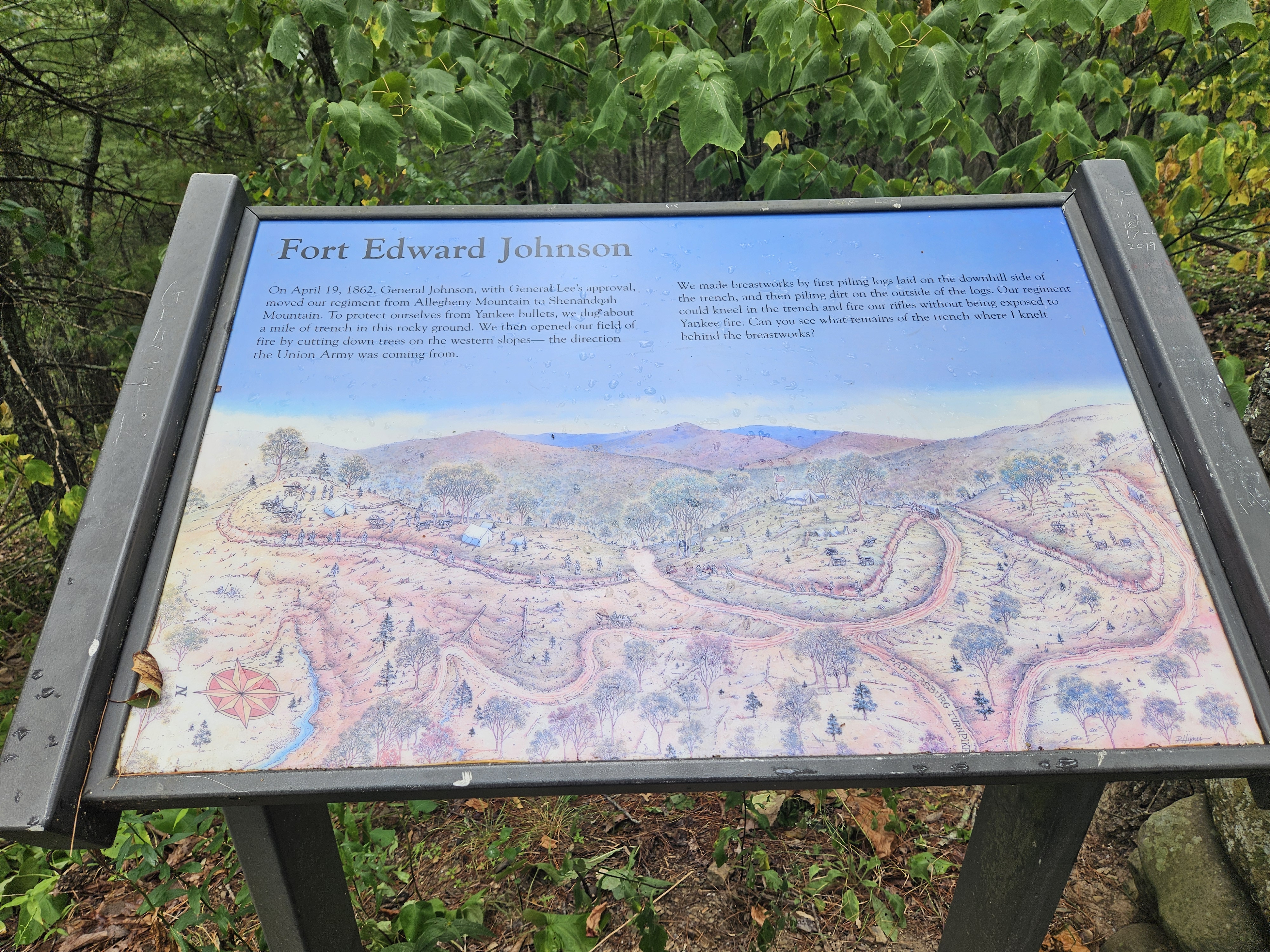
Confederate troops, the remnant of the Army of the Northwest commanded by Brig. Gen. Edward “Allegheny” Johnson, constructed this fortification about 1 Apr. 1862 to protect the Shenandoah Valley, the “Breadbasket of the Confederacy.” Federal troops briefly occupied the fort after he withdrew to West View near Staunton later that month. With Maj. Gen. Thomas J. “Stonewall” Jackson’s Army of the Shenandoah, Johnson’s command confronted Union forces under Brig. Gen. Robert H. Milroy and Brig. Gen. John C. Fremont at the Battle of McDowell on 8 May. Johnson’s ankle was shattered during this first victory in Jackson’s famous Valley campaign.
*
And then I stopped randomly at a scenic overlook and learned more about Fort Edward Johnson and the Confederate breastworks still vaguely visible in the landscape. But I was burning daylight and just indulged a quick skim of the area's many sites.
 |
| https://www.hmdb.org/m.asp?m=30389 |
 |
| Where I was (McDowell), where I am (Fort Johnson), and where I am going (Staunton, then North and home). |
 |
| Not really a marker, but a good map. |

 |
| https://www.hmdb.org/m.asp?m=255037 |
As “Stonewall” Jackson’s Army passed through the gap on their way to McDowell, Virginia one soldier wrote:
Tuesday 13th May 1862
I have been struck with the wild & mountain scenery. The Shenandoah Mt. Pass is grand indeed, you ascend to the very top of the mountain & from there you see as far as the eyes can reach, Mtn. after Mtn. in every variety of shape & grandeur whilst away down below a little valley & stream with winding road, winding around from Mt. to Mt. to descend the grade. After reaching this valley we asend the hd waters of the James to a point where the waters turn the other way & then we discerned the headwaters of the Potomac. The Mts. tower above us beautifully.
Every now & then you will find a fresh & sparkling stream gushing out of the mtn. side & running away into the larger streams of the Valley….
Diary of Frank B. Jones
Major, 2nd VA Infantry
Major Jones was later wounded at McGehee’s Mill and succumbed to typhoid.
 |
| https://www.hmdb.org/m.asp?m=208803 You are standing in the middle of what was once Fort Edward Johnson. Confederate soldiers built this fort in 1862 under the command of Brigadier general Edward Johnson, a career officer from Virginia. Look to your right, and then left across the highway for what remains of the mile of trench and breastworks. They were built by Confederate soldiers to defend the Shenandoah Valley from an invasion by Union Troops marching from the west. In the early spring of 1862, this fort was garrisoned by 3,000 troops, primarily from the 12th Georgia Regiment. Most of these troops were stationed four miles to the east at Camp Shenandoah, where there was good drinking water and pasture for their horses. By May of 1862, General John C. Fremont’s Union Army, under General Robert Milroy, was moving toward the fort from the west. “Stonewall” Jackson’s Confederate Army retreated out of the Shenandoah Valley leaving a chance that the fort would be cut off from the rear by Union forces. General Johnson’s troops evacuated the fort. They moved toward Staunton only to find Jackson’s army had returned to Staunton in a lightning move that surprised both the Union generals, and Jackson’s own staff. General Johnson’s men joined Jackson’s Army and marched back through the fort, which had been occupied by advance Union troops. The combined Confederate Army continued its march through these mountains on the Parkersburg Turnpike until it reached the small village of McDowell, Virginia, where the main Union Army was encamped. On May 8th “Stonewall” Jackson’s Army, after suffering heavy losses, sent the Union forces into full retreat and relieved the threat to Staunton. |
 |
| https://www.hmdb.org/m.asp?m=16773 |
My name is Shepherd Green Pryor, but my friends and family call me “Shep.” I was elected First Lieutenant of the Muckalee Guards, Company A, 12th Regiment, Georgia Volunteer Infantry. We’ve just survived a cold Virginia winter on the top of Allegheny Mountain – a long way from our warm homes in Sumter County, Georgia.
Walk with me on this 0.5-mile trail while I share with you my experiences guarding Fort Johnson during the spring of 1862. Through my letters home to my dear wife Penelope, I hope you can understand how lonely I am for home, and how this awful war has changed or ended the lives of the young soldiers who once kneeled in these trenches.
 |
| https://www.hmdb.org/m.asp?m=16775 |
On April 19, 1862, General Johnson, with General Lee’s approval, moved our regiment from Allegheny Mountain to Shenandoah Mountain. To protect ourselves from Yankee bullets, we dug about a mile of trench in this rocky ground. We then opened our field of fire by cutting down trees on the western slopes – the direction the Union Army was coming from.
We made breastworks by first piling logs laid on the downhill side of the trench, and then piling dirt on the outside of the logs. Our regiment could kneel in the trench and fire our rifles without being exposed to Yankee fire. Can you see what remains of the trench where I knelt behind the breastworks? [Yes, kinda...]

 |
| https://www.hmdb.org/m.asp?m=16776 |
February 23, 1862
My Dear Penelope,
I write a few lines this morning to let you know that I am well & doing as well as I have since Iv been in the service.
Well, Dear, wee had an alarm Friday knight about two o'clock, and the way wee got around quick untwill we were all way ready was a site. The regiment formed & was ready in ten minutes. March up to the intrenchments, got in the ditches and they were hald full of snow. It was cold business, sure. I marked time for three hours to keep my feet from freezing, but when the day dawned wee did not have to fight; I don’t want to fight as long as wee can do as well without it. I don’t want to be shot at; some of them stand a good chance to hit a fellow. I want to see the close of the war & live at home a free man once more.
Give my love to all my friends. Kiss the babies for me.
I am yours,
Shep
*This letter was actually written from Camp Allegheny, but was included because of Lt. Pryor’s description of going into battle.
There was more of that story on that trail, but like I said - no time. I may or may not ever make it back. But meanwhile, on the way out of the mountains...
 |
| https://www.hmdb.org/m.asp?m=62920 |
Mountain House
Jackson's March
—1862 Valley Campaign—
The Battle of McDowell began three miles to the southeast (near the intersection of Routes 629 and 716) when Confederates were fired upon by Union cavalry on May 7, 1862. After skirmishing, Federals rushed to the base camp here, sounding the alarm as they rode through.
A Northern cavalryman wrote, “Our company was the only company in the fight. They were the furthest company out – five miles beyond Shenandoah Mountain. They were cut off by Johnson’s force, and the only way they had to get back was to fight their way, which they did nobly. We lost but one man [but] had six horses killed in the road, and ten more shot that will never get well.”
This land was part of a farm abandoned by Henry Ryan, a prosperous settler who had moved from the area because he was a pacifist. On May 8, 1862, a Staunton diarist wrote, “General Johnson surprised the Federal scouts, some 200 cavalry, on yesterday at Ryan’s in the Pastures… Cannonading was heard today from early morning till four o’clock p.m. in the direction of Shenandoah Mountain.”
Georgia troops had camped in Ryan’s fields while stationed atop Shenandoah Mountain. After they abandoned Camp Shenandoah on April 19, Federals advanced to this point, with cavalry stationed to the east as pickets.
“The enemy… had retreated up the Shenandoah Mountain but we supposed was still holding our ‘Fort Johnson’ at the pass on the top. The General ordered me to go up the spur of the mountain on our right, preceded by a line of skirmishers…. We had to scramble up a steep slope but finally reached the top only to find the enemy all gone but seeing their rear guard on the top of Shaw’s Ridge.” – Jed Hotchkiss, Stonewall Jackson’s mapmaker, May 7, 1862.
 |
| Useful orientation of recently visited sites. And this is why I take the back roads. |
 |
By Jedediah Hotchkiss - This file is from the Mechanical Curator collection, a set of over 1 million images scanned from out-of-copyright books and released to Flickr Commons by the British Library.View image on FlickrView all images from bookView catalogue entry for book., Public Domain, https://commons.wikimedia.org/w/index.php?curid=57395442 |
https://www.hmdb.org/m.asp?m=32910
*
And then, in March of 2026--while visiting 1862 sites in West Virginia--I passed through McDowell again. This time, in addition to briefly visiting the museum/mansion house, I took the long "arduous" hike up the mountain to the actual battlefield. It was a couple miles straight up in bear country; I had bells on my bag to warn them away. And just like in the real Civil War, a broken ankle could have been a death sentence since there was NO cell phone reception and nobody else on that long lonesome trail. Worth it for the stunning views and to collect the following markers. First: the Mansion House, also skipped the first time through.
 |
| Rogue marker here: same contents as Z-110, but different location - since 1929. |
 |
| The road to McDowell - deer in road. |
 |
| https://www.hmdb.org/m.asp?m=235786 |


*
And then the McDowell Battlefield rail...
 | |
| OH what a trail! All 15 stops...here I come. Erected 2022 by Shenandoah Valley Battlefields Foundation. |
 |
| https://www.hmdb.org/m.asp?m=239058 |
Confederates Hold the High Ground
The Battle of McDowell (May 8, 1862)
Beyond the Ridge you are facing is Sitlington's Hill. On the afternoon of May 8, 1862, Confederate Gen. Edward "Allegheny" Johnson directed two brigades of Confederate infantry to take position on the hill facing the Federals across Bullpasture River in front of the Village of McDowell. As the afternoon grew late, the Federals crossed the swollen Bullpasture River using the Staunton-Parkersburg Turnpike bridge and advanced Johnson's position. The Federals gained some success until the Confederate line was stabilized by the arrival of Confederate reinforcements, including Gen. William Taliaferro's brigade of Confederate Gen. Thomas J. "Stonewall" Jackson's Valley Army.
The Federals launched a furious attack against the Confederate center as Taliaferro and his regiments came onto the field.
As darkness fell, the fierce volleys continued claiming heavy casualties on both sides. Confederate Col. Samuel Gibbons of the 10th Virginia was killed, and Gen. Johnson was removed with a severe ankle wound. Shortly before 9 pm, the Federals broke off their unsuccessful attack, burned their camps and began to retreat toward Franklin.
The drawing by artist Alfred Waud, is a stylized depiction of Union soldiers attacking heights held by Confederate soldiers as was done at the Battle of McDowell.


 |
| https://www.hmdb.org/m.asp?m=239089 |
Two Plans Of Attack
The Battle of McDowell (May 8, 1862)
When he arrived in McDowell on May 8, 1862, Confederate Gen. Thomas J. "Stonewall" Jackson rode to the top of Sitlington's Hill. There he studied the terrain and Union positions in the village below with Confederate Gen. Edward "Allegheny" Johnson, who was commanding the southern troops on the field. Jackson decided against bringing his cannon atop the height, not wanting to risk losing them in the rocky terrain if he was forced to hurriedly withdraw.
Instead, believing that no major fighting would occur that day, Jackson decided to move his artillery behind the Federals. He instructed his mapmaker, Jedediah Hotchkiss, to find a route behind the Union army and to have the artillery in place by 3 am on May 9 for an attack that day.
But the Federals had other plans. As the Confederates deployed on Sitlington's Hill, Union Gen. Robert H. Milroy and his superior, Gen. Robert C. Schenck, agreed to make a reconnaissance-in-force to learn more about the threat they were facing - a decision accelerated by a rumor that Confederate artillery was being placed on Sitlington's Hill. Milroy believed that they "must at once take the aggressive or abandon the field." He was determined to "deliver a blow, if we could, and then retire from [Jackson's] front before he had recovered from the surprise."
The die was cast. As the Confederates were getting into position at the top of Sitlington's Hill, Union troops crossed the river and moved up a ravine in the Confederate front.
"I made a reconnaissance for the purpose of obtaining accurate information of their (the Confederates) strength and position."
- Union Gen. Robert H. Milroy

 |
| https://www.hmdb.org/m.asp?m=239156 |
Moving Uphill
The Battle of McDowell (May 8, 1862)
At 5:30 pm during the Battle of McDowell, the second line of Confederate infantry moved through this area as they climbed to the top of Sitlington's Hill to reinforce the defenders who had been battered by the initial assaults.
The Federals had begun their attack around 4:30 pm, as Union Gen. Robert H. Milroy's 2,300 men climbed up the steep western slope of Sitlington's Hill and attacked the first line of Confederate defenders. Confederate commander Gen. Stonewall Jackson had not expected an assault by the outmanned Federals. As the battle grew in intensity, and with the Confederates pressured along the line, he deployed his reserves on the slopes around you, and men rushed uphill to reinforce the threatened points along the line.
As the troops started up the hill, some passed near a field hospital, and saw "the ground strewn with the wounded, the dead, and [the] dying" as the surgeons did "all they can to save suffering and life." Moving through here, they saw other stricken soldiers coming "down the ridge from the front, wounded and red with blood," some carried on litters, others stumbling along as best they could.
Ahead of them, looking up the mountain, they could see the thick smoke of battle, and hear officers shouting commands, the crash of gunfire, the oaths and cries of soldiers engulfed in battle, and the shrieks of those hit by shot and shell.
The sights and sounds were sobering. Confederate Sgt. Osborn Wilson of the 31st Virginia no doubt spoke for many of his fellow soldiers as they marched towards the fighting: "God of many help and make us brave and prudent."
Caption:
Confederate troops on the march, as seen by Southern artist Allen C. Redwood. Image courtesy of The Project Gutenberg.


 |
| https://www.hmdb.org/m.asp?m=239178 |
The Ravines
The Battle of McDowell (May 8, 1862)
As they advanced to combat, both armies used ravines to make their way to the top of Sitlington's Hill. Most Confederate troops used a ravine just off to your left, which provided a direct route to the top of the height.
During the battle, Confederate Gen. Thomas J. "Stonewall" Jackson remained on the Staunton-Parkersburg Turnpike and directed reinforcements up through that ravine and over the ridge behind you to Confederate Gen. Edward "Allegheny" Johnson's beleaguered Confederates at the top of the hill. Jackson also placed the 31st Virginia Infantry along the pike near the bottom of the ravine to prevent Union infantry from using it as an avenue to get behind the Confederates.
Federal troops used a ravine on the other side of the height to advance up the western slope of the hill. Union Col. Nathaniel McLean's attacking force, consisting of the 25th Ohio and 75th Ohio Infantry, crossed the Bullpasture River, then followed a road that ran parallel to the river for several hundred yards before turning to the left and starting up the ravine.
Progress through the ravines was slow, tedious, and tiring. The rugged terrain took a heavy toll on the troops - even before they neared the top and the horrible inferno of battle.
Caption:
The Ravine Confederates used to climb Sitlington's Hill as seen from Route 250.


 |
| https://www.hmdb.org/m.asp?m=239197 |
The Confederate Right
The Battle of McDowell (May 8, 1862)
You are looking toward the Confederate right flank. At the beginning of the battle, this flank extended toward the Staunton-Parkersburg Turnpike at the bottom of the hill to your right. The main Union attack came against this part of the Confederate line. As the Union pressure mounted, the Confederate position was in peril.
Reinforcements under Confederate Gen. William A. Taliaferro arrived from the Staunton-Parkersburg Turnpike over the ridge behind you and hurried into line. As the battle progressed, the right flank was bent back at a right angle to combat the building pressure. The thick smoke and setting sun led to chaos on the battlefield.
Confederate Gen. Edward "Allegheny" Johnson, who was in command of the forces on the ridge, was severely wounded in the ankle and had to be removed from the battlefield., and Taliaferro assumed command. Confederate Gen. Thomas J. "Stonewall" Jackson, who was directing reinforcements from the valley below, sent his mapmaker, Jedediah Hotchkiss to find Taliaferro and instruct him to hold his position.
Hotchkiss recalled that he "scrambled up to the top of the mountain where the fighting had been going on, but which had then ceased but a short time. Everything was confusion - the men all mixed up and hunting for the wounded and reforming in anticipation of another attack." After delivering his message to Taliaferro, Hotchkiss rejoined Jackson, where they shortly received word that the battle had ended.
Captions:
Jed Hotchkiss.
Courtesy of Encyclopedia of Virginia
A Federal flank attack. Image courtesy of Library of Congress

 |
| https://www.hmdb.org/m.asp?m=239207 |
Sitlington's Hill
The Battle of McDowell (May 8, 1862)
Sitlington's Hill was heavily wooded with thick underbrush and several rocky slopes, made for hard fighting. Both armies used ravines that traversed around and through the hill during the battle. The top of the ridge has a knoll to the left and a knoll to the right with a depression in the middle.
A Confederate soldier described the hill as looking like "the back of a Bactrian camel, the two humps rising 800 feet and 1,200 feet above the bottomlands below, "...broad but was rugged and had many sharp ridges and ravines on its surface. In front of it, a smooth slope dropped down sharply to the Bull Pasture River, about 500 feet below...a ridge that ran North and South, and at right angles to the turnpike."
Today the Hill looks much like it did during the 1862 battle. The path you are walking on was possibly used by some Confederate reinforcements during the battle.
"A position almost impregnable if defended with reasonable skill and courage." - PVT. E Z. Hays 32nd Ohio
Caption:
Sketch of Sitlington's Hill by Sgt. Oscar Ladley 75th Ohio Infantry.

 |
| https://www.hmdb.org/m.asp?m=239254 |
The Battle Rages
The Battle of McDowell (May 8, 1862)
"Many of the boys had their guns shot to pieces... They would pick up another gun and go to work as usual."
- Pvt. Ephraim Hutchison, 82nd Ohio Infantry, USA
You are standing along the Confederate defensive line during the Battle of McDowell. Beginning around 4:30 pm that day, and continuing for some four hours, Union soldiers advanced doggedly uphill toward this position, loading and firing as they came. On either side of you, Confederate soldiers returned fire with grimy musket barrels and suffering heavy casualties.
The assault by Federals, who were both heavily outmanned and attacking from an inferior position, came as surprise to Confederate commander Gen. "Stonewall" Jackson and his troops.
Union soldiers used ravines to minimize their exposure to the defenders' fire as they moved uphill. Although greatly outnumbered, the Union regiments moved steadily up the steep and rugged slopes and inflicted heavy losses along the Confederate line. The northerners' rifled muskets allowed them to fire more accurately and at longer ranges, and the setting sun silhouetted the southerners against the sky, making them easy targets - while the shadows of the mountain side hid the Federals from view, and Confederate fire aimed downslope at the attackers tended to go too high.
But although the Confederates came under heavy pressure, reinforcements rushed up the hill to this point stabilized the line, and the Confederates held. As the darkness grew, and with Federal troops running low on ammunition, Union Gen. Robert H. Milroy reluctantly ordered a withdrawal, and the Federals pulled back down the mountain to McDowell.
Caption:
This drawing depicts Union and Confederate soldiers fighting intensely just as they did at McDowell. Image courtesy of Library of Congress


 |
| https://www.hmdb.org/m.asp?m=239270 |
The 12th Georgia
The Battle of McDowell (May 8, 1862)
During the Battle of McDowell, the Confederate 12th Georgia Infantry held this ridge, overlooking the Village of McDowell. The Georgians began the battle on a knoll - a "large hilly old field" - in advance of the main Confederate line before being pushed back.
The Georgians were in an exposed position, as the ground forced them to form their lines in an inverted "V", subjecting them to attack from left, right and center, and they suffered heavy casualties. They were also outgunned, as the regiment was equipped with .69 caliber smoothbore muskets, whose range was just over 100 yards, while their Federal counterparts used rifled muskets with greater range and more accuracy.
A Union charge forced the Georgians back into a basin higher up the hill, but the men of the 12th did not retreat entirely. Instead, whenever Confederate Col. Z. T. Conner, in command of the 12th, would persuade one wing the other wing would advance back to their forward position. When later asked why they wouldn't withdraw, one soldier replied, "We did not come all this way to Virginia to run before the Yankees."
As the evening began to fall, the Georgians had moved to where you are standing, at the middle of the Confederate line, and they fought desperately to help hold off Federal attacks. Silhouetted against the clear sky by the setting sun, they were easy targets, and continued to suffer heavily - but helped hold the line.
By the end of the battle, the 12th Georgia suffered more losses than any other Confederate unit on the field, with 52 men killed and 123 wounded out of a total of 540 men engaged, a loss of over 32%.
"We did not come all this way to Virginia to run before the Yankees."
- Georgian soldier
Captions:
John James Carson Co. D 12th Georgia Infantry. Wounded at McDowell.
Image courtesy of the American Civil War Museum.
Capt. James W. Patterson Co. I 12th Georgia Infantry.
Killed at McDowell.
Image courtesy of the Confederate Veteran Magazine.
John A. F. Jarrell Co. B 12th Georgia Infantry. Fought at McDowell.
Image courtesy of the American Civil War Museum.


 |
| https://www.hmdb.org/m.asp?m=239302 |
A Spectacular Show
The Battle of McDowell (May 8, 1862)
As night fell, the battle still raged. The growing darkness falling made it difficult to see the enemy, and soldiers resorted to firing at their opponent's muzzle flashes in the woods.
Frank S. Reader, a post-war newspaper editor and member of Company I, 5th Virginia Infantry (Union) at McDowell, wrote: "The flashing of the guns after nightfall on the mountainside and crest, amid the trees, was indescribably grand and beautiful, and no one witnessing it can ever forget it. At times lighting up the whole mountainside, and again the flash from one or a few muskets made a scene of particular beauty and animation."
When darkness finally overtook the battlefield, Union Gen. Robert H. Milroy reluctantly recalled his battle-weary soldiers from the mountainside. After receiving the recall order, Union Col. Nathaniel McLean marched his men to the base of Sitlington's Hill. There he halted and faced his men toward the enemy on the ridge. While McLean's men stood guard, the other three Ohio regiments made their way down the hill. Upon reaching the mountain's base, the Ohioans were joined by the 3rd Virginia Infantry (Union).
As one body, they then marched back to their camps on the opposite side of the Bullpasture River. The four-hour battle had come to an end.
Caption:
Depiction of Union soldiers facing the enemy line awaiting orders. Sketch by W. L. Sheppard


 |
| https://www.hmdb.org/m.asp?m=239320 |
An Attack Repulsed
The Battle of McDowell (May 8, 1862)
When the Federals launched their attack, the 25th Ohio and 75th Ohio assaulted this position on the Confederate left. The defenders here included the 52nd, 58th, and 44th Virginia Infantry, with the 52nd on the far left.
The Union soldiers enjoyed initial success as they slogged up the hill pushing the Confederate pickets placed on the lower slopes up the hill. As the Federal soldiers reached the main Confederate line, here however, they were met with rapid volleys of intense musket fire, and the advance stalled. But the northerners refused to retreat and held their ground for the remainder of the battle.
The fighting along the ridgeline grew in intensity farther to your right as the 82nd and 32nd Ohio sent by Union Gen. Robert H. Milroy engaged the Confederates. Pushed back by southern reinforcements, the 82nd and 32nd Ohio ascended the hill again, but this time approached this part of the line. Through the thick smoke, the Confederates suddenly saw a Yankee flag just 50 yards away. After exchanging musket fire, the Confederates broke in confusion. Desperate to hold this flank, Confederate Col. W. C. Scott, of the 44th Virginia rushed forward with his hat in his hand and shouted to the retreating soldiers, asking them, "If they intended to let the D----d Yankees drive them from their own soil."
The effect of this plea was instant. The Virginians about-faced and delivered a deadly volley into the advancing enemy, sending them reeling. As the northern troops retreated, Scott's men gave "three cheers for old Virginia."
Caption:
The above photo depicts a Union attack on a Confederate battle line. Image courtesy of Library of Congress


 |
| https://www.hmdb.org/m.asp?m=239358 |
A Reconnaissance In Force
The Battle of McDowell (May 8, 1862)
When the Federals launched their attack at the Battle of McDowell, Union Gens. Robert C. Schenck and Robert H. Milroy intended it as a "reconnaissance in force," an attack designed to test the strength of the Confederate line.
Confederate Gen. Edward "Allegheny" Johnson's troops waited along this ridge. Johnson's left flank rested on this hill, and the right extended to your far right, where it bent back along the ridge.
The 75th and 25th Ohio regiments under the command of Union Col. Nathaniel McLean climbed the western face of Sitlington's Hill and attacked the 12th Georgia, which was posted in advance of the main Confederate line. Progress was slow, and as the Federals advanced into the open ground, they faced a Confederate force several times their size. Despite a devastating fire from the southerners, the Federal troops continued their ascent. McLean said his men "steadily advanced up the precipitous ascent, firing and loading with great coolness." Hand-to-hand combat ensued, and some Confederates were driven back.
When the Ohioans approached the Confederate main line here, they came under a galling fire that stalled their advance. For 90 minutes the Ohioans fought in this position without assistance. Although the most intense fighting shifted toward the right and center of the Confederate line, combat continued in this area, and the 25th and 75th steadfastly held their ground until being recalled by Milroy after nightfall. McLean praised his men, saying, "they worked together with great coolness" and "without a thought of retiring."
"We were posted along the crest of this hill...We are within range and their bullets whistle about us... We return the fire. More of the enemy now make their appearance from the valley below and they seem resolved to drive us from the hill. A battery opens on us from a hill near the village, but our (position) is so high that the balls pass over us without doing much harm." - Charles C. Wight, 58th Virginia
Caption:
Union soldiers attacking uphill as they would have at McDowell. Image courtesy of Library of Congress

 |
| <3 |
Big one. Plenty of links/info out there:
https://www.battlefields.org/learn/civil-war/battles/mcdowell
https://en.wikipedia.org/wiki/Battle_of_McDowell
https://www.shenandoahatwar.org/battle-of-mcdowell
https://www.nps.gov/articles/000/battle-of-mcdowell.htm


Comments
Post a Comment