July 11, 1861
Battle of Rich Mountain
Randolph County, WV (Beverly is the nearest town, but that's a world away from this mountain peak)
Gen. George B. McClellan; Gen. William S. Rosecrans
vs
Gen. Robert E. Lee: Gen. Robert S. Garnett > Lt. Col. John Pegram & Capt. J.A. deLagnel
* A key moment in the early war: here is where McClellan's initially winning reputation is first built...on Rosecrans' efforts. And here is Lee failing. Of course, it wouldn't take long for those circumstances to be dramatically reversed.
* Also a key moment in my own Civil War tourism/obsession, as Rich Mountain almost killed me on my first trip there (see below).
 |
| Prologue: Truly a mystery. There's not even a ping on the map to indicate what was previously displayed on this sign . It's outside Mabie, WV on the way up Rich Mountain. Not atypical for West Virginia... |
 |
On the way up, approaching Rich Mountain from the West, like the Yanks, I first encountered this non-historical marker: "Private" park?! I guess I'll keep it moving. I found no signage at the site of Camp Garnett. And those next "2 miles" took a long time: very slow, hairpin turns, all the way up the mountain. I never saw a single other other person from this point, to the top, and all the way back down, which was even slower and curvier.
And here is supposed to be Camp Garnett, near the base of the mountain. There are allegedly as many as six historical markers here. I couldn't find any! Even after taking the little bridge over Roaring Creek - still nothing. Still: let me dump some info from the signs that were maybe at this location in the past. I perhaps missed the site of Roaring Creek Flats ("2 miles west")--is that Field of Fire?-- but I couldn't find anything on the map. |
Camp Garnett
Rich Mountain Battlefield Civil War Site
Confederate Stronghold Guarding the Staunton-Parkersburg Turnpike
Confederate Brigadier General Robert S. Garnett ordered fortifications built here to control the turnpike and hold western Virginia for the South. The fort, built of earth and log entrenchments, overlooked the vital road. By July, 1861, Colonel John Pegram commanded Camp Garnett with 1,300 Virginia troops and four cannon.
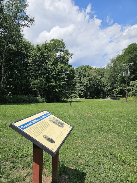
Union Major General George B. McClellan was charged with securing western Virginia for the Union. On July 9, 1861, he brought over 5,000 troops to Roaring Creek Flats, two miles west of Camp Garnett. Hesitant to attack the well-entrenched Confederate position, McClellan sent Brigadier General William S. Rosecrans with 1,917 troops on a roundabout route to the south up Rich mountain. Guided by David Hart, whose family lived at the pass, the Federals' goal was to capture the turnpike above and behind Camp Garnett.
Gen. Robert S. Garnett
was killed at Corrick's Ford while retreating from his former position at Laurel Hill. He was the first Civil War general to fall in battle.
Gen. George B. McClellan
was called to Washington to lead the federal Army of the Potomac as a result of the victory at Rich Mountain.
Staunton-Parkersburg Turnpike
connected the Shenandoah Valley with the Ohio River and gave access to the vital B&O railroad. The battle to control western Virginia began at Philippi, with Union victory secured at Rich Mountain and Corrick's Ford. During the remainder of 1861, Union troops at Cheat Summit Fort faced off against Confederates at Camp Barlow, then Camp Allegheny, but Federal forces remained in control of the strategic road.
&
General McClellan marched three brigades of Federal troops into position along nearby Roaring Creek. He ordered a strong scouting party up this road to test the Camp Garnett defenses on July 10, 1861. Withering infantry and artillery fire from the Confederate fortifications convinced McClellan that a direct attack was folly. Instead he plotted to strike Camp Garnett from two directions.
"I have been looking at the camps with my glass - they are strongly entrenched..."
-George McClellan
&
Confederates built Camp Garnett to block the Staunton-Parkersburg Turnpike. Soldiers here felled trees, dug trenches and stacked rocks for protection. Fortifications covered the hills overlooking this road, forming a fearsome obstacle for General McClellan's army.
"The regiment will be able to hold five times their number in check… if they will stand to their work."
-Confederate General R.S. Garnett
Then, finally, I reached the battlefield itself, atop a lonely mountain. Glorious views all around.
 |
| https://www.hmdb.org/m.asp?m=165110 |
Battle Of Rich Mountain
Making McClellan's Reputation
— The First Campaign —
In the spring of 1861, Union forces rushed into northwestern Virginia to secure the vital Baltimore and Ohio Railroad, protect important turnpikes, and support Unionists against Confederates. The two sides fought numerous engagements between June and December. They included Philippi (the war's first land battle), Rich Mountain, Corricks Ford, Cheat Summit Fort, Carnifex Ferry, and Camp Allegheny. The many Union victories made Gen. George B. McClellan's reputation and damaged that of Confederate Gen. Robert E. Lee—a situation reversed in 1862. Despite later Confederate raids, today's West Virginia remained largely under Federal control for the rest of the war.
In one of the first important Union victories of the Civil War, on July 11, 1861, Union Gen. George B. McClellan's forces defeated part of Confederate Gen. Robert S. Garnett's command here at the Hart Farm on Rich Mountain. Garnett was holding the area around Beverly, the junction of two important turnpikes: the Beverly and Fairmont and the Staunton and Parkersburg. Believing that the Rich Mountain defenses were virtually impregnable, Garnett had left a small force here under Lt. Col. John Pegram to hold this pass. Union Gen. William S. Rosecrans attacked uphill in a pouring rain and overran the Confederate position. That night, the Confederates abandoned Camp Garnett, their fortification at the western base of the mountain, and fled east through dark woods. Two days later, almost 600 of them surrendered to McClellan in Beverly. Others escaped south, guided by Stonewall Jackson's future mapmaker Jedediah Hotchkiss.
This small but important victory helped secure Union control of Virginia's western counties and contributed to the drive for West Virginia statehood, which was achieved in 1863. It also helped to catapult McClellan to command the Army of the Potomac.

 |
| https://www.hmdb.org/m.asp?m=23539 |
The battle was fought in this pass along the Staunton-Parkersburg Turnpike. Union forces led by General William S. Rosecrans stormed down the hill behind you. Confederates on guard here took cover behind log breastworks, farm buildings and large rocks in the stable yard across the road. Federal soldiers were held back by fire from infantry and single cannon. After three hours of fighting, the larger Federal force charged and captured the cannon, scattering Confederate defenders through the woods.
 |
| https://www.hmdb.org/m.asp?m=238863 |
General Rosecrans led a brigade of nearly 2,000 Union soldiers through dense wilderness to the summit of Rich Mountain. His guide was young David Hart, son of a family living here at the pass. Leaving camp on Roaring Creek before dawn, Rosecrans' column climbed silently up the mountainside to flank Camp Garnett and strike the enemy rear. The battle began about 2:30 p.m. on July 11, 1861, when advancing Union troops encountered Confederate skirmishers.
"The whole earth seemed to shake."
-David Hart, Rich Mountain guide
 |
| https://www.hmdb.org/m.asp?m=23584 |
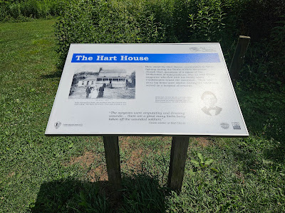
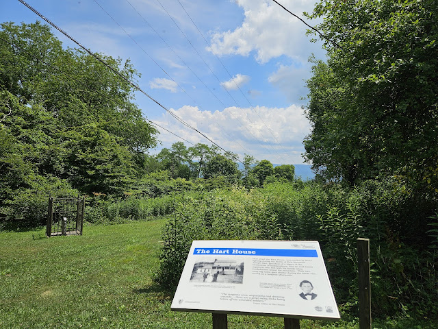
Here stood the Hart House, surrounded by fierce fighting during the Battle of Rich Mountain. Joseph Hart, grandson of a signer of the Declaration of Independence, was an avid Union supporter who fled with his family when Confederates seized the mountain. Their two-story log home gave shelter during the battle and served as a hospital afterwards.
"The surgeons were amputating and dressing wounds... there are a great many limbs being taken off the wounded soldiers."
-Union soldier at Hart House.
 |
| https://www.hmdb.org/m.asp?m=165313 |
 |
| https://www.hmdb.org/m.asp?m=262241 |
Originally a source of water for the Hart family, this spring house served an important role during the Civil War. Some claimed the family took shelter here during the Battle of Rich Mountain, but tradition suggests they left before the fight. Soldiers of both armies filled canteens at the spring house. After the battle, the spring house provided life-giving water for the wounded.
"[We received a canteen as a war memento] it was filled with water...from a spring on top of Rich Mountain, directly between the two fires of battle. We all took a drink of it." -Diary of Marcia Phillips, July 20, 1861
This wooden structure rested on the same stacked stone still visible today.
 |
| Path to the spring |
 |
| Remnants of the spring itself: "the same stacked stone[s]" |
 |
| https://www.hmdb.org/m.asp?m=23585 |
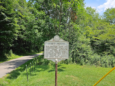
Battle of Rich Mountain fought here July 11, 1861. In a surprise attack, Gen. W.S. Rosecrans defeated Confederates led by Capt. J.A. deLagnel. Battle was decisive in McClellan's N.W. Virginia campaign.
(West Side):
Rich Mountain battle was waged near Hart House and barn where deLangel's 310 men held Rosecrans' forces for 4 hours before surrendering. This forced Col. Pegram to retreat. His army was captured.
Interesting that this clearly older sign is the first to mention deLangel. His Wikipedia page offers additional details about his role during the battle: manning the gun.  |
| https://www.hmdb.org/m.asp?m=23590 |
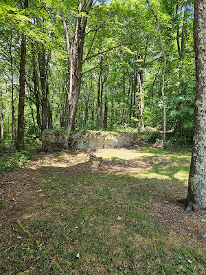
Here in the stable yard, Confederate forces made their stand. A small log stable was the focal point of action. Large foundation stones still mark its location. A lone Confederate cannon stood beside the stable, blasting furiously during the battle. Young Southerners faced their first fire against overwhelming odds, yet drove back two Federal assaults before giving way.
"As regiment after regiment of the enemy came into view, our small force saw it had heavy work..."
-Confederate Captain David Curry
 |
| Barely visible carvings on the "large foundation stones" that date back to the battle. Hard to see/read, but still cool! |
 |
| Got'em all! Eventually |
And from the museum in Beverly...
This site from the Beverly Heritage Center seems to confirm that I did, in fact, mess up badly and miss Camp Garnett, while I was 2.5 miles away. Maybe when I come back for Carnifex Ferry... |
There's just one more thing..
* * *
What if I told you that this was actually my second attempt to reach the Rich Mountain battlefield... and I almost died the first time? Here's the story...
I woke up very early in Parsons, WV. At least I knew I had to make some preparations and take some precautions, but I was not prepared enough. I anticipated that I would never be able to drive from home and see all the sites I wanted to see in WV, so I got this little Airbnb. I had plenty of warm clothes, extra food and water, and never let my gas tank fall bellow half-filled. It would prove to still be insufficient advanced preparation. Since this trip (Dec. 2022), I have updated my car with better all-weather tires - and I added a spare tire. I knew I would need printed versions of maps, anticipating the lack of signal. Another mistake I made was printing out directions to the sites I wanted to visit - but not mapping an escape route home.
Just a few flurries fell as I set off, and I was excited to check out Corrick's Ford on my way to Rich Mountain. Alas, I would never make it up that mountain this time.
 |
| Looking like a psycho at Corricks Ford before dawn. |
I was too preoccupied to take any real photos of the death-defying nightmare fuel later, but this picture provides some hints. Taken outside of Parsons on the way to Beverly, this view shows the deteriorating road/weather conditions - and the unfinished end of the highway I was later travelling on. So: picture that icy road but way up on those giant pylons in the sky, and my tiny Hyundai slipping all over the road. I was travelling so slowly--for hours--that I ended up sliding backwards a few times - and may have hit the guardrails (softly) more than once. The time I saw my life flash before my eyes was one such sliding incident when my car was heading directly for the gap between the road's guard rail and the start of a bridge; the pics above and here gives some sense of the deep ravine I was staring down at the time.
As I reached Beverly, conditions were worsening slightly, but I still would categorize it as a light snow. |
| Oldest Public Cemetery West of the Alleghanies?! Where am I? |
And here's the first hint that I have made a terrible mistake. I'm trying to see all the things from the Eastern theatre, but I got greedy (what with my desire to complete all of 1861) and crossed the mountains. I wasn't the first white man to get in trouble for doing so! I pushed quickly through Beverly, trying to reach the summit of the Mountain--and the town of Mabie beyond--before the weather got worse. I could not make it-this time. Most people know this, but it turns out that the light flurries I was experiencing at the bottom of the mountain were nothing compared to the blizzard at the top. And, perhaps more relevantly, the roads were completely unplowed. I should not have been there, but getting out was the easiest part of the still-developing challenge. To road up Rich Mountain would turn out to be the least of my problems that day, despite going very badly in its own right.

After leaving Beverly to wind my way up Rich Mountain road I stopped seeing other cars, until I finally saw one. A pick-up truck was heading my way, coming down the mountain, so I eased over to the right to let him pass - and promptly found myself in a ditch (see above). At first, I didn't even realize I was in trouble, but I am eternally grateful that the man driving the truck stopped to clarify the direness of my situation: my car's right-side wheels were no longer making contact with solid earth, my cell phone had no reception, and nobody would be coming by for the duration of the storm. Maybe I was lucky that it was right around Christmas time because the good Samaritan offered to call me a tow-truck. Then he was on his way. True to his word, nobody came up or went down the mountain road for the hour or so that that I waited alone watching the snow accumulate. Some of that time the car was running to keep me alive. (For readers who may have found themselves here from my other/music blog, the apropos soundtrack was Weyes Bloods' excellent 2002 album And in the Darkness Hearts Ago, which had just come out and that was my first full listen.) Eventually, I saw a tow truck in the distance twisting up the mountain road towards me. He yanked me out of the ditch and pulled me down to the next bend in the mountain. Then I began slowly, slowly crawling back down. Although the snow kept falling I had no real choice but to keep travelling, first back through Beverly then retracing my early journey back to Parsons. As I pointed my car homeward, the real fun began. And the snow kept falling.
 |
| Look back down the winding mountain road, waiting for the tow |
I was unable to take a single picture during the worst of it, but the landscape was like something out of Middle Earth and difficult to conceive as American. Trying to get home from the middle of WV, I travelled east across the very crest of the Appalachian Mountains on a horrifying causeway in the sky. I don't mean to be hyperbolic here, but according to the road's wiki page, it "crosses very mountainous terrain, some of the most rugged in the eastern United States." I had no business being there in my little Hyundai during a blizzard. The only other vehicles I saw for miles and hours were giant ice-road truckers, clearly equipment for whatever the hell they were doing up there.
One of the worst parts, was that there were so few off-ramps from the ice road in the sky. I couldn't get off to pee or anything! Once I realized that was the pattern, an exit only every 50 miles or so, I abandoned my Eastward trek - and ill-advised attempt to squeeze in a few more WV sites. I cut my losses and headed straight North for Keyser, WV, relying entirely on seeing that recognized name on a road sign and following it until I saw another road sign telling me which way to go. My phone's service and navigation worked not at all until I eased back into familiar Western Maryland by Cumberland, just as the roads began to clear up. Lesson(s) learned: I came back in the Spring, when the driving was slightly easier!
 |
| That much snow |
 |
| Then coming down from the mountains and suddenly getting much better |
 |
(Almost) home sweet home: I've never been so happy to see Western Maryland - and a flat, paved modern highway. *
|






Comments
Post a Comment